A FULL DAY OUT TO EL TORCAL, FUENTE DE PIEDRA AND EL CHORRO
IMPORTANT to note about this page is that it was originally put on this site many years ago, before Sat Nav but I would still recommend that you try to follow the route as it will take you the more scenic attractive roads. Although you should be aware that there may well have been some diversions due to new roads having been constructed over the years.
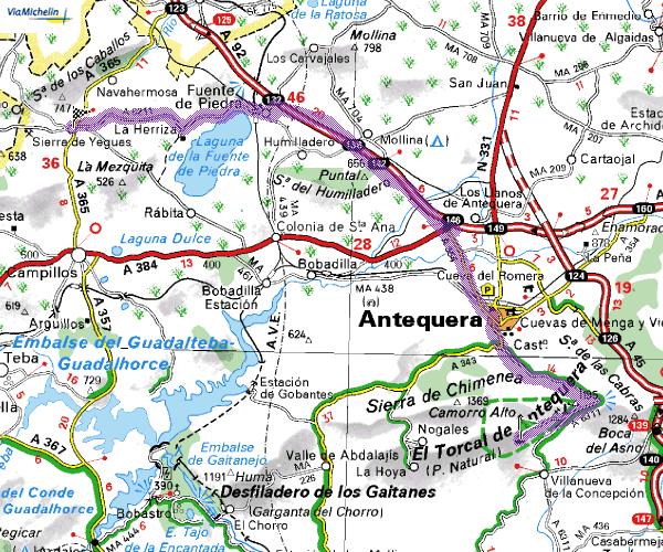
This stage is to Fuente de Piedra via Antequerra and is 26 miles (42 kilometres)
and takes around 40 minutes
As this site is strictly relative to Benalmadena and Arroyo de la Miel that is where we will begin the journey. Set off on the motorway to Malaga. At Malaga stay on the motorway and follow the signs to GRANADA and ALMERIA. When clear of Malaga the motorways split and you need to come off to the right following the blue signs to GRANADA & ANTEQUERA. At Casabermeja (JUNCTION 148) slip off following the signs for VILLANUEVA DE LA CONCEPCION. You do not go into the village of Casabermeja, once you have passed under the motorway you immediately turn right and run parallel to the motorway until you reach a T junction – turn LEFT following the signs for ALMOGIA & LA VILLA EL TORCAL.Stay on this road and follow it into VILLANUEVA DE LA CONCEPCION in the town the road branches right and is signed EL TORCAL 6 and ANTEQUERA 18.

Enjoy the scenery, don’t drive too fast and take in the views – after 6 km (3.75 miles) look out for the turning off on the left to EL TORCAL (you have to double back on yourself) Although there is a barrier and what appears to be a toll hut you do not have to stop and admission is free. Keep climbing until you reach the the car park at the top
This part of the trip is 42
miles (68 Kilometres) and takes around 1 hour
IN THE WINTER MONTHS REGARDLESS OF THE TEMPERATURE ON THE COAST DO TAKE
A CARDIGAN OR TOP COAT AS IF CAN STILL GET CHILLY IN THE MOUNTAINS
– IN THE SUMMER MONTHS IT IS OFTEN HOTTER THAN THE COAST
LEAVING EL TORCAL, ONWARD TO FUENTE DE PIEDRA.
Leave El Torcal by the same road down to the park entrance where you turn LEFT signed ANTEQUERA 12. Once in ANTEQUERA town you arrive at a T junction.
If you turn right it takes you in to the old town centre of Antequera and it is well worth a look.
But for now turn LEFT following the signs for SEVILLA. You are faced with a “monumental” roundabout which you need to go round on the right and then take the right fork keeping the gardens and park area on your left. Proceed through the town, down the hill past the “Eroski” supermarket following the BLUE motorway signs for SEVILLA (A92). You do not join the motorway for about 3 miles where there are a couple of tricky turns, take it slowly and remember that you are following the BLUE signs for SEVILLA. Stay on the motorway for around 7 miles (12 Km) coming off at JUNCTION 132 signed ALMEDRA – FUENTE DE PIEDRA and LAGUNA DE FUENTE PIEDRA which is your destination.
On the edge of the village you reach a crossroads and if you are following all of this route you will probably be ready for a cup of coffee, a drink or breakfast. So head into the village centre where you will find typical spanish Bars and restaurants.
If you want to carry on then go straight across the crossroads into the village and continue to follow the signs to LA LAGUNA. Just as you leave the village you will cross a railway bridge then take the “turn right to turn left” turn into the reserve.
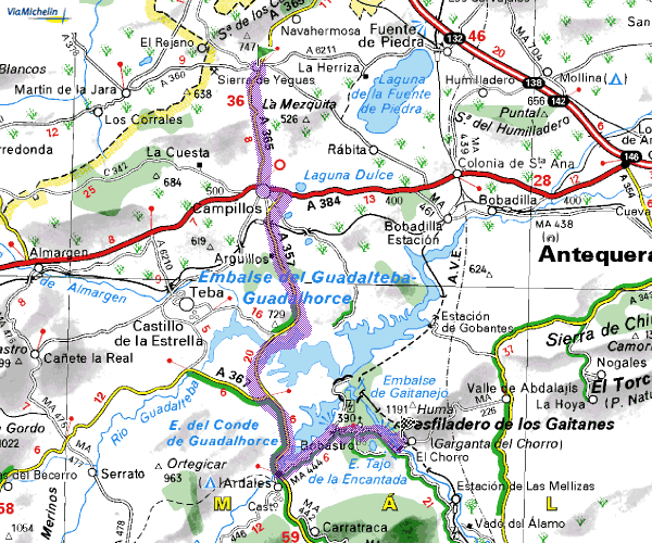
LEAVING FUENTE DE PIEDRA, ONWARD TO EL CHORRO
Back on the road again as you leave the reserve turn left following the signs to SIERRAYEGUAS which follows the lake for most of the way – and if you are wondering they are olive trees
on arriving in SIERRA DE YEGUAS turn LEFT at the new roundabout and into the village. Drive right through the village And turn left at the new roundabout onto the new road to Campillos.
On arriving in CAMPILLOS you will meet a T Junction – to the left it is signed ANTEQUERA and you may fancy a diversion as there are several large leather outlets as this is the regional centre for all kinds of leather goods. Handbags, coats, jackets, belts and boots etc.
THE SCENIC ROUTE BACK TO BENALMADENA
However to keep on track turn RIGHT on the outskirts of the village you pass through more factory outlet type shops and workshops just beyond these look out for another of the “turn right to turn left” SIGNS, signed CAMPILLOS 1 – RONDA 61. this takes you through the town go straight across the first roundabout the town square and park area will be on your left at the next roundabout follow the RONDA sign to the right (beware of the first turning which is actually a car park) after leaving CAMPILLOS after around two miles take the RIGHT FORK onto the A357 to MALAGA – follow the MALAGA signs for 12.5 miles (20 km) where you turn RIGHT
off the main road towards ARDALES also signed EL CHORRO immediately the road doubles back on itself and there is a T Junction. Turn RIGHT signs to EL CHORRO EMBALSES (RESERVOIRS) and now the trees are Almonds the road that follows the lake side is not a through road but it is well worth the diversion at least as far as the dam, take a drive over the dam and through the hamlet to a car park on the right where it is worth turning round.and retracing the route to the MA 444 EL CHORRO- ALORA turn off .
After passing the hydro electric the next turning on the left is across the main dam as you cross the dam you will see the “Restaurante Garganta” directly in front but high above you. Follow the road up the hill round the hairpin bend A hundred yards or so beyond the giant eucalyptus tree in the centre of the road there is a parking area. Park here or a little further on at the railway station. This used to be a GREAT spanish restaurant but has long since changed hands and sadly we have since been disappointed,
This stage is to Benalmadena Costa and is 42 miles (65 kilometres) and takes around 1hr 15 min’s