|
|
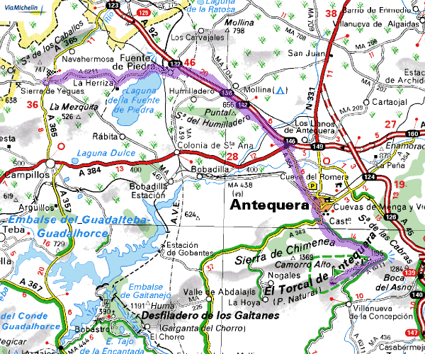
| As this site is
strictly relative to Benalnadena and Arroyo de la Miel that is where
we will begin the journey. Set off on the motorway to Malaga. At
Malaga stay on the motorway and follow the signs to GRANADA and ALMERIA. When
clear of Malaga the motorways split and you need to come off to the right
following the blue signs to GRANADA & ANTEQUERA. At Casabermeja
(JUNCTION 148) slip off following the signs for VILLANUEVA DE LA CONCEPCION. You
do not go into the village of Casabermeja, once you have passed under
the motorway you immediately turn right and run parallel to the motorway
until you reach a T junction - turn LEFT following the signs for ALMOGIA
& LA VILLA EL TORCAL.Stay on this road and follow it into VILLANUEVA
DE LA CONCEPCION in the town the road branches right and is signed EL
TORCAL 6 and ANTEQUERA 18. |
IN
THE WINTER MONTHS REGARDLESS OF THE TEMPERATURE ON THE COAST DO TAKE
A CARDIGAN OR TOP COAT AS IF CAN STILL GET CHILLY IN THE MOUNTAINS
- IN THE SUMMER MONTHS IT IS OFTEN HOTTER THAN THE COAST
This part of the trip is 42
miles (68 Kilometres)
and takes around 1 hour
click here for info & pics
of El Torcal
|
| Enjoy the scenery,
don't drive too fast and take in the views - after 6 km (3.75 miles)
look out for the turning off on the left to EL TORCAL (you have to double
back on yourself) Although there is a barrier and what appears to be
a toll hut you do not have to stop and admission is free. Keep climbing
until you reach the the car park at the top |
| |
|
| Leave El Torcal
by the same road down to the park entrance where you turn LEFT signed
ANTEQUERA 12. Once in ANTEQUERA town you arrive at a T junction. If
you turn right it takes you in to the old town centre of Antequera and
is well worth a look. But for now turn LEFT following
the signs for SEVILLA. You are faced with a "monumental" roundabout
which you need to go round on the right and then take the right fork
keeping the gardens and park area on your left. Proceed through the town,
down the hill past the "Eroski" supermarket following the BLUE motorway
signs for SEVILLA (A92). You do not join the motorway for about
3 miles where there are a couple of tricky turns, take it slowly and
remember that you are following the BLUE signs for SEVILLA. Stay
on the motorway for around 7 miles (12 Km) coming off at JUNCTION 132
signed ALMEDRA - FUENTE DE PIEDRA and LAGUNA DE FUENTE PIEDRA which is
your destination. |
This
stage is to Fuente de Piedra via Antequerra and is 26 miles (42 kilometres)
and takes around 40 minutes
|
On the edge of the
village you reach a crossroads and if you are following all of
this route
you will probably be ready for a cup of coffee, a drink or breakfast. So
if you turn right, you will find a typical spanish restaurante
(La Laguna) about 100 yards on the right hand side. If
you want to carry on then go straight across the crossroads
into the
village and continue to follow the signs to LA LAGUNA. Just
as you leave the village you will cross a railway bridge then take
the "turn right to turn left" turn into the reserve.
|
 |
|
| |
|
| Back on the road
again as you leave the reserve turn left following the signs to SIERRA
DE YEGUAS which follows the lake for most of the way - and
if you are wondering they are olive trees - on
arriving in SIERRA DE YEGUAS turn LEFT at the new roundabout and into
the village. Drive right through the village And turn left at the new roundabout onto the new road to Campillos. |
This stage
is to Parque Ardales & El Chorro and is 40 miles (64 kilometres)
and takes around
1hr 30 mins
|
On arriving
in CAMPILLOS you will meet a T Junction - to
the left it is signed ANTEQUERA and you may fancy a diversion as there
are several
large leather outlets
as this is the regional centre for all kinds of leather goods. Handbags,
coats, jackets, belts and boots etc. However
to keep on track turn RIGHT on the outskirts of the village you pass
through
more factory outlet type shops and workshops just beyond these look
out for another of the "turn right to turn left" SIGNS, signed CAMPILLOS
1 - RONDA 61. this takes you through the town go straight across
the first roundabout the town square and park area will be on your
left at the next roundabout follow the RONDA sign to the right (beware
of
the first turning which is actually a car park) after leaving CAMPILLOS
after around two miles take the RIGHT FORK onto the A357 to MALAGA
- follow the MALAGA signs for 12.5 miles (20 km) where you turn RIGHT
off
the main road towards ARDALES also signed EL CHORRO immediately the
road doubles back on itself and there is a T Junction. Turn RIGHT
signs to EL CHORRO EMBALSES (RESERVOIRS) and
now the trees are Almonds the
road that follows the lake side is not a through road but it is well
worth the diversion at least as far as the dam, take a drive over the
dam and through the hamlet to a car park on the right where it
is worth turning round.and retracing the route to the MA 444 EL CHORRO
- ALORA turn off . After passing the hydro electric the
next turning on the left is across the main dam as you cross the dam
you
will see the "Restaurante Garganta" directly in front but high above
you. Follow the road up the hill round the hairpin bend . A
hundred yards or so beyond the giant eucalyptus tree in the centre
of the road there is a parking area. Park here or a little further
on at the railway station.
Click here
for info & pics about Restaurante Garganta |
| |
|
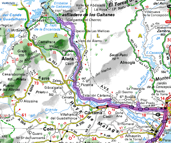
| So I really do
hope you appreciated that meal as much as we always do, but now back
down the hill over the dam and turn LEFT and follow the signs to ALORA this
time the trees are Lemons and later Oranges No
major problems on these roads keep following the MALAGA signs and you
will skirt ALORA and then PIZZARA with citrus groves all the way. The
only place you may find a problem is as you approach MALAGA on the A357
be alert for the blue sign off to TORREMOLINOS and ALGECIRAS which takes
you onto the main coast road and back to Benalmadena. From door
to door I make that 150 miles exactly (240 Km's) around 5 hours driving
time through some of the most astounding scenery in Andalucia with more
variety than the average holidaymaker or ex pat is aware even exists. |
This stage
is to Benalmadena Costa and is 42 miles (65 kilometres)
and takes around
1hr 15 min's
|
| |
|
| If you hire a car
to do this route please feel free to print this itinerary, it has been
designed to print off in four separate A4 pages with a map on each. Should
you prefer to be "chauffeur driven" please contact us for details of
our MPV service we drive you sit back and relax in air conditioned comfort
and take advantage of the extended lunch. Click here to contact
us |
| |
|
|